.jpg)
After nearly five straight days under extreme cold warnings, southern Manitoba is finally seeing some relief.
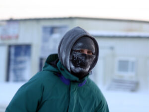
Environment Canada ended the extreme cold warnings just before 4 a.m. Monday, bringing an official close to a bitterly cold snap that began Wednesday afternoon and gripped nearly the entire province.
While Monday morning still began with frigid wind chills near –38 for Winnipeg and several other locations, temperatures are expected to become more manageable throughout the day. Winnipeg is forecast to reach a high of –15 this afternoon, though wind and blowing snow could still make conditions challenging in rural areas.
Warming trend this week for Manitoba
The shift marks the beginning of a slow and steady warming trend across southern Manitoba. Although temperatures will remain well below freezing, daytime highs for much of the week will hover in the minus mid-to-high teens, with overnight lows generally in the minus 20s.
By the weekend, forecasters expect highs to climb to around –10 or even single digits below zero by Sunday, offering a noticeable improvement from the dangerously cold conditions seen over the past several days.
Frostbite is still possible with morning wind chills below –30 through mid-week, so residents are advised to continue dressing warmly and exercising caution, especially during early morning hours and overnight.
While some flurries and blowing snow are possible Monday, the rest of the week is expected to bring mainly clear and sunny skies.
Find your full weather details anytime on the Jani-King Weather Page.